UPDATE: Apparently, the G in gerrymandering is a hard G*
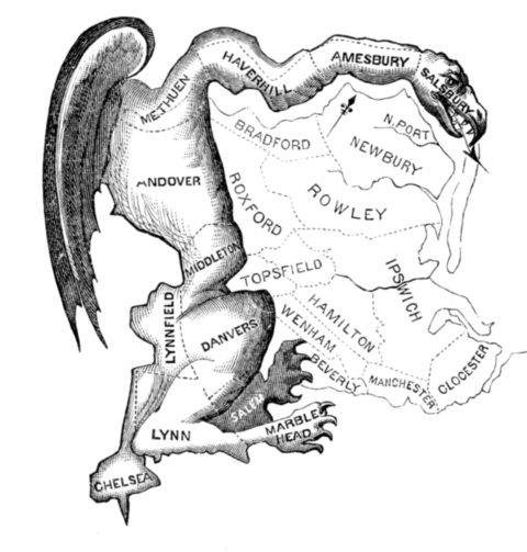
Moving the political goalposts – Gerrymandering is the deliberate design of voting districts to achieve a specific outcome other than fair representation in a governmental election. It is named for US Governor Elbridge Gerry of Massachusetts, who signed the Massachusetts Senate Redistricting Bill of 1812 that included several “creatively” drawn districts designed to ensure his political party’s continued majority in the state senate. This less than ethical approach to democracy continues unabated in many parts of the world to this day.

Wikipedia cites examples of gerrymandering in modern times in Australia, Canada, Chile, France, Germany, Greece, Hong Kong, Hungary, Ireland, Kuwait, Latvia, Lithuania, Malaysia, Malta, Nepal, Philippines, Singapore, Sudan and the UK…but of course, the vice is used elsewhere and in particular in the home of gerrymandering the USA. Gerrymandering is essentially precluded in Israel and The Netherlands because there is only a single voting district for elections there.
Lunday explains that in the US, at least, for House of Representatives as well as state legislatures, political districts exist to ensure elected representatives are responsible for and accountable to the residential constituents from local geographic regions rather than representing a state at large, lest a legislator be potentially more accountable to a political party. As populations grow and relocate, so boundaries must be shifted periodically to ensure fair representation. It is at these times that gerrymandering can be carried out to shift the political focus of particular regions, which has to be considered an unfair exploit within a democratic system.
Lunday has looked at the 16 main shapes and compared 80 different combinations to find the metrics associated with each that might be combined into a single figure to define whether gerrymandering has or has not been implemented. He has also calibrated the metric against recent “redistricting” plans. He has proposed a method for evaluating objectively the shape of political districts based on the presence of undesirable geometric characteristics such as puncturedness, indentation, elongation, and separation, the presence of which portend the absence of compactness and/or contiguity, he says, the metric was calibrated against court decisions by federal courts and the Supreme court on boundary changes. Tests of the metric against human judgment of whether or not gerrymandering took place are highly correlated (correlation coefficient of 0.804, which means a little over 8 times out of 10, the metric was right to say whether gerrymandering took place or not).
![]() Lunday, B.J. (2014) ‘A metric to identify gerrymandering’, Int. J. Society Systems Science, Vol. 6, No. 3, pp.285—304.
Lunday, B.J. (2014) ‘A metric to identify gerrymandering’, Int. J. Society Systems Science, Vol. 6, No. 3, pp.285—304.
In case you hadn’t realised my headline and graphic is a joke, there was no Gerry Mander in this context, rather, the word is a portmanteau of Massachusetts Governor Elbridge Gerry’s name, with “salamander” and was coined in a famous cartoon showing “The Gerry-Mander”, this political satire lampooned the way in which Gerry had adjusted borders to favour specific candidates in the 1812 elections.

*Elbridge Gerry New England politician whose political map inspired the cartoon, pronounced it with a hard G. https://www.wsj.com/articles/attention-america-weve-all-been-saying-gerrymander-wrong-1527178009